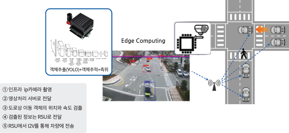
Cooperative sensing technology for infrastructure-to-AV communication (V2I)

  • Cooperative sensing technology that shares blind spot information from infrastructure to vehicles using V2I communcations.
  • A control center processes /img from cameras installed on vehicle blind spots (such as at intersections) and delivers the detected information i real time to the autonomous vehicle (e.g. Ive) through V2I communication

Demand-responsive shared autonomous shuttle development

  • The first shared autonomous shuttle service in Korea (2017-2019)
  • Demand-responsive service
  • Uses Wave/WiFi and V2X commucations based on a wireless mesh network
  • Implementation of cooperative sensing shares blind-spot information with vehicles by cooperating with fixed infrasturcture with V2X communcation
  • Using LiDAR, cameras, V2X commuinications, the shuttle can sense nearby pedestrians and other dangerous objects. The shuttle has operated accident-free.
  • Application of fusion positioning technology that matches magnetic induction methods with high-repcision 3D maps includeing cameras & LiDAR sensor information

Development of an autonomous driving system and AI driving verification simulator

Traffic-related big data management platform.

  • Development of a data management system that can effectively process real-time data collection and storage of traffic-related big data as well as location-based queries
  • Development of a highly scalable data management system using distributed parallel computing environements
  • Development of query-processing technology that conisders the temporal and spatial properties of /img and text of moving objects

Mobility Research

Mobility Modes Classification
  • The trajectory data of moving objects is classified by mode, such as bus, subway, taxi, car etc.
  • Mobility mode predction for real-time trajectory data
OD (origin-destination) points with stay points research
  • Demand forecasting through the analysis of start/end points of journeys based on stay length
Analysis of driving behaviour by mobility mode.
  • Analysis of driving behaviour by mobility mode
  • In the case of a passenger car driver, a relative driving behaviour (score) analysis between users driving the same route at the same time

Development of an AI autonomous vehicle platform

  • Improving the 360-degree omnidirectional object detection and recognition accuracy through the fusion of LiDAR, radar, and camera sensor data
  • Securing recognition performance to respond to ruban road driving environments such as traffic light colours and stop lines.
  • Improving the detection performance of driveable areas through the recognition of unstructured environments
  • The advanced conversion of driver control rights (i.e. take-over commands) by preparing for unexpected events and determining whether autonomous driving is possible

Indoor position and navigation platform (WalkingMap)

Many of use have experienced the feeling of being lost and wandering in an indoor space.

Now, the WalkingMap web application can guide you using augmented reality within indoor spaces.

  • WalkingMaps is able to position the user using fixed markers (QR codes affixed to the ground) and does not require any power, complex installations, or maintenance. All that is needed is a smartphone with a web connection.